This blog is a little longer than usual, so grab a beer and enjoy the ride:
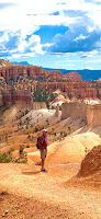
Dangling from cables 2,000’ above the canyon floor on Angel’s Landing in Zion National Park, one begins to questions their motives, especially after looking at the trail entry sign where the Park Rangers had crossed out the number of deaths. But on the bright side, this is a poignant reminder of how life is so precious and to never let go no matter how tough it gets. Because the real challenge in life is taking fear and turning into yet another eye popping experience. So kudos to Loraine with her freshly recovered hip replacement and plated broken wrist, she never skipped a beat, scaling the beast, and danced on the top of one of the iconic views in the world.
 |
| ANGEL'S LANDING |
 |
Loraine dangling
from the top edge |
 |
| VIEW FROM THE TOP |
The idea for this 6 week journey was a camping/ hoteling trip to Mt Rushmore in Big Red, our 26 year Chevy Tahoe, hoping she was up for another adventure. But as I skimmed through the Zion bookstore I stumbled upon a book called: “The Grand Circle of National Parks" by Eric Henze. Have you heard of it? Me either.  |
| The Grand Circle through 4 states |
The funny part was we had planned the trip a long time ago and had accidentally covered 5 of the 7 national parks listed on the front cover, and we even started in the same order of the book at Zion. Go figure. So off we went on this side adventure following the books unique historical approach to our incredible National Park system in the U.S.
Turns out the Grand Circle contains the highest concentration of National and state parks in the country. Within a 500 mile diameter there are almost 80 parks and other attractions.
But the question begs why here? Well, according to the book this area is part of the Colorado Plateau, one of the most geological stable places on the earth. Over time this has allowed the gouging of canyons by rivers, rain, wind and other natural forces, and in the process has carved mind boggling giant monoliths.
 |
| Zion lodge |
The word Zion was introduced by the Latter Day Saints, and means “pure of heart”, to me it means full “purity of the soul”. One can’t help looking at the 2,000 feet red sandstone walls in this 15 mile box canyon and get butterflies inside. We stayed at the rustic Zion lodge which had been renovated for the last time in the 1990s. And although the lumpy bed wrecked havoc on my back, they had excellent, inexpensive food, including the best in house black bean burger I have ever tasted!
 |
| The Narrows |
The crown jewel of the park is the Narrows, carved out by the Virgin River. We ended up walking knee deep against the current of the river in the Narrows on the same day we did Angel’s landing (highly not recommended- couldn't move our legs the next day). We river walked in awe as the sides of the canyon closed in on us, the further you go up the more the walls closed in. Upon hearing thunder, and aware a flash flood could arrive at any minute we turned around in a soft pelted rain. Two days later we found out there was a flash flood that swept away a young lady in the Narrows and was found dead several days later- Yipes!
I recommend a minimum of 3 days exploring Zion.
 |
Hike to the
Amphitheater |
Bryce National Park: We got up bright and early and headed on the Zion Canyon Scenic Dr (UT-9E) to Bryce Canyon. This route has a more windy turns but the never ending views take you away. Stunning water and wind carved sandstone features will greet you upon the entrance of the park. Bryce Canyon, is named after the Mormon Ebeneezer Bryce, who had a cattle ranch there in 1875, they even have an Ebeneezer bar at the entrance of the park.  |
| The Hoodoos of Bryce |
Bryce canyon was formed differently than Zion, as it was not dug out by a river. Bryce being at 9,000', is the product of the rain, and snow melt. And as we know when water freezes it expands, cracking the softer limestone. When the temperatures rises and melts the water, it follows a path of least resistant, carving the pointy, spiral Hoodoos, as it meanders through the limestone. One cannot get the true insight of the intricacies of Bryce canyon from the top, you have to submerse yourself by taking a trail down into what is called the amphitheater.
We decided to take in the hoodoos along the Tower’s Bridge Trail, 4 miles in and out. Every turn is breathtaking and somewhat different, each has its own special shaped Hoodoos, and when the light hits the red orange sandstone you feel like you just stepped into fairytale land.  |
| Tower's Bridge |
There are campgrounds and a old lodge to stay in Bryce, so allow 2/3 days to explore the diversity of this park
 |
View from the upper
floor of Boulder Lodge |
Off to Capitol Reef National Park, but first we had to stop at what turned out to be one of the highlights of our trip. Recommended by Sandy and Bob Irwin the Boulder lodge, which is found in Torrey (great name), Utah. If you upgrade to the top floor, you will be gazing out into a really unique flourishing wildlife sanctuary. Go into the community room and you can use their telescopes and you might as well get a full free body massage in one of their massage chairs.
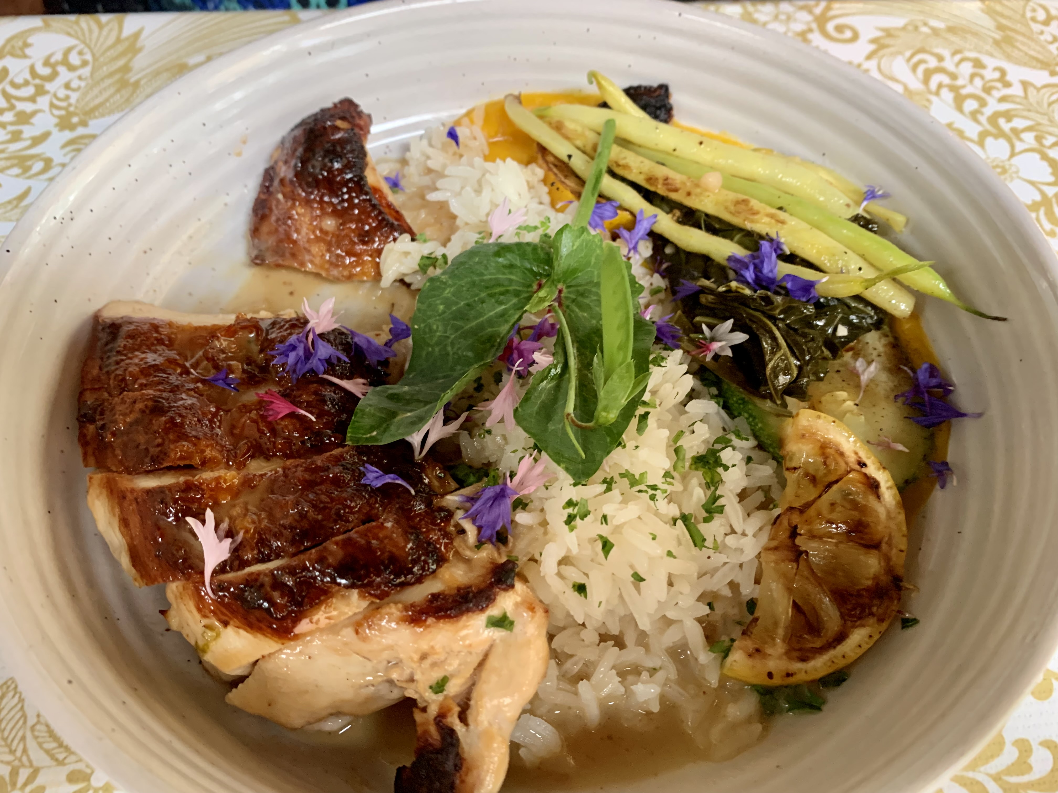
Another recommendation was by Matt Cunningham who said you have to try this fabulous restaurant by the property called: “Hell’s Backbone Grill”. The winner of many culinary awards, and with a Southwestern dazzle. They have unique dishes such as Pueblo Rice, Spicy Cowgirl Chipotle Meatloaf, lemony Chuck, and Piñon-Sage Stuffed Zucchini. And a James Bond martini to die for… shaken not stirred, with Beehive Vodka made from sugarcane-yummy.  |
| Hell's Backbone Grill |
 |
| Lemony Chuck dish |
Capitol Reef National Park: So I will answer the question you are thinking right off the bat, why call it Capitol Reef? Well, there is huge rock formation that looked like our nation’s capitol and was the go to point for travel orientation back in the 1800s. And the reef comes in because there are layers of flakey sandstone called a monocline, the largest example in North America, and resemble the shelf shape of coral reef formations.

 |
| Shale like reef rocks |
Although there a myriad of hikes to take and a scenic drive for 16 miles, the little oasis town of Fruita is fascinating. Fruita was founded by Mormons around the 1880s. They had established a farming like atmosphere which include orchids of peaches, plums, apples, pears, walnuts and almond trees, pretty impressive since it is smack tab in the middle of the desert. We did a quick hike to the Hickman bridge, but along the way what caught my eye was the trailhead sign which read: Cohab Canyon. After doing a little research the folklore talks about how in late 1800s the Federal law officials would come and raid the town of Fruita.

 |
| Strawberry Rhubarb pie-yum |
The Feds were looking for polygamist, so the menfolk would take all the wives except for one and hike up and hide them in Cohab canyon until the officials left. When the officials came the Mormons would use the phrase, “ all those other beds were for guests”, is actually pretty creative on their part. You can’t leave Fruita without stopping by Gifford’s pie shop, fresh made pies each day. We tried strawberry rhubarb, add a scoop of ice cream and now you really have a slice of culinary heaven. I recommend at least 2 days in Capitol Reef National Park. There are some nice hotels just outside of the park entrance, and a delightful campground right in the middle of Fruita with some partial tree coverage and great views.
 |
Loraine enjoying her morning
coffee by the streamAlta ski area: |
 |
| Trail up to Sunset peak |
We stopped the Grand Circle experience for our side jaunt to Mount Rushmore. Along the way we did our first camping at Tanner Flat campground in little Cottonwood canyon off Veterans Memorial Hwy on the way to Provo. I love this area because of the history and beauty of our country's oldest ski area- Alta. A great campground well shaded, with a cool sites along a rushing stream. We liked site 25 and 33. The only problem was we had rain, almost everyday, and unbeknownst to us, a leaky tent, and so we started each day with a little soaked through feeling. The highlight here was a cool hike up past the Alta ski area at the end of the road. You pay $10 to drive up a dirt road a little further to cut off 2 miles hiking. This way you start off the hiking through Switzerland like valleys to Sunset Peak, @4-5 miles round trip.
At the top spectacular views capture the entire region of Alta, and Brighton ski areas. About 7-8 years ago me the boys: Bill, Spike, Dick and Gary did an Epic ski day. Skiing 5 ski resorts in one day we crossed the Wasatch range starting in Park City and ending in Alta and Snowbird. Skiing the backcountry powder, and negotiating the thin iced “Trail to the Sun" was a hair raising experience and yet to be matched. At the top of Sunrise Peak, I couldn't see the treacherous “Trail to the Sun”, a 12" wide path of melting ice on the side of a bowl we crossed, we had to stay 15' apart as we traversed the transparent thin ice, with a 1000' breakthrough fall. Little scary to say the least.  |
Everything is bigger in
Rawlins, Wy-no glasses
needed for this menu! |
 |
| 1850 carvings |
 |
| Independence Rock |
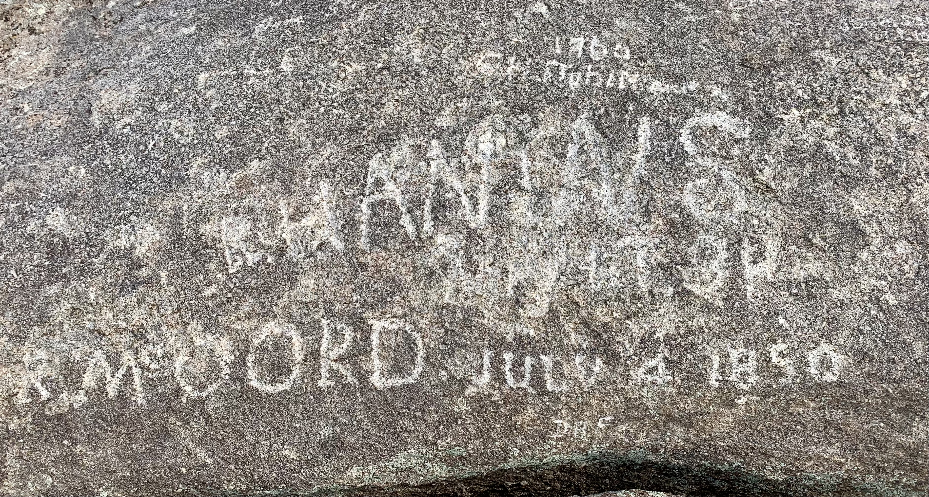
Back on the road outside of Rawlins, Wyoming, we saw what a appeared to be a giant “Ayer’s”- like rock formation called Independence Rock. I had to stop and climb this granite outcropping. About 130 feet tall, 1,900 feet wide and 850' wide, not much of a climb, but there was a reward at the top. Etched out on the granite boulders were the names of the western traveling pioneers going all the way back to 1850. They were on their way to the west and they knew if they made it to Independence Rock by July 4th, they could cross the Rockies before winter settled in.Mount Rushmore National Monument is truly a patriotic experience, I felt rejuvenated as an American as I read and heard about the accomplishments of these superstars. Sculptured by Gutzon Borglum, son of Danish immigrants, he spent the last 14 years of his life overseeing this feat from 1926-1941. In his studio he would design the figureheads to 1/12 of the scale and then he used a plumb bob tool pitched off the top of the sculpture to carve the figures, although, interesting enough, over 90% of the stone was blasted away from the cliffs. But why were these presidents getting such an honor? Because, all of them were instrumental in shaping our country. George Washington headed up the continental army and was our first president, he helped lay the foundation of democracy. |
| George Washington |
 |
| Mt. Rushmore |
Thomas Jefferson consider by many to be our most brilliant President, not only was the principal author of the Declaration of Independence, he had the foresight to negotiate with the French for the purchase of the Louisiana Purchase, and this nearly doubled the size of our country.
Abraham Lincoln, of course restored our union in the Civil War, and issued the preliminary Emancipation Proclamation, the first step to end slavery.
 |
| Abraham Lincoln |
 |
| Teddy Roosevelt plaque |
Teddy Roosevelt was honored for his vision of linking the Atlantic to Pacific ocean as he negotiated the building of the Panama Canal. FDR, unfortunately was left out, and in my opinion he did at least as much as those 4 presidents. He was our longest serving president and accomplished the ending of the depression with the New Deal, several banking acts, and fired up the country for WWII when Japan attacked us at Pearl Harbor….But he could not be honored since we was the president during the time of construction of Mt. Rushmore, 1926-1941. Disillusioned Biology Teacher: Another interesting fact is the plaque underneath Teddy Roosevelt. The plaque says nothing about his conservation accomplishments. He of course was my favorite president, even though he was an avid hunter. So I stormed into the visitor center and found a ranger named Anne, couldn’t have been more than 20. I said, "what’s the deal with the plaque not mentioning Teddy’s conservation contributions"! She politely said, in a calm voice: “he had established the following: 150 National Forests, 51 Federal bird reserves, 4 National game reserves, 5 National Parks, 18 national monuments, over 230 million acres of public land”. I said, “wow”, she said, “his environmental accomplishments were not really appreciated until many. decades later. He was chosen for being a world leader and the realization of the Panama Canal.” I said, with my tail between my legs,” thank you”.
So after seeing these amazing accomplishments by former presidents, I have to ask what has happened to our country over the past decade? I am perplexed! I think this whacked out sign on the front side of a restaurant in Keystone city, next to Mt. Rushmore sums up the anger, and misinformation going on today….Patriotism be dammed!, people don’t know what it looks like anymore.

One of the prime candidates to blame is the internet, with easy access to social media. Anyone can write anything with no facts to back it up, and it is just their opinions. So here’s one idea I think might help, an easy, accessible nonpartisan fact checking site, at the top of each Facebook, Twitter posting, etc., where one can see the facts- one such site is: FactCheck.org. And as my brother Ken said, " we need to get rid of the Special interest lobbyists and PAC groups." These groups funnel money to the politicians to get them to vote for their self-serving agendas, this is probably where the phrase: "I have you in my back pocket", came from. Maybe a certain amount of our taxpayer's money, including the luxury taxes, goes into a campaign fund which each of the candidates divide up.
Bigger than the Internet, there seems to be a fundamental chasm between parties without looking into ways to solve the issues..it is either my way or the highway. As the 4 great presidents showed us there will always be a division between the haves and have nots, but with great leadership we can work through most of those issues.
So how do we start fixing this dichotomy….by listening to each others insights on the problem, not yelling over each other, and then compromise. I think both sides of the lines actually agree on many of the problems facing the country. For example, immigration, the country was founded on the open door policy of letting people come to our country and going through processing at Ellis Island in New York. Our country wanted to grow in numbers and strength while practicing certain freedoms. But the paradigm has shifted over the centuries, and what does that mean nowadays? Our health care is overburdened, as is public school funding, welfare programs are abused..etc. The policies definitely needs an overhaul while taking in all sides of consideration. And if we look at our past, presidents like Teddy Roosevelt and Richard Nixon, staunch Republicans, by the way, saw the bigger picture of how wilderness areas, clean water and air acts were beneficial to all Americans. We can’t allow the voices of the few who are angry, self entitled, and prejudice fuel our leaders. Time to start working from the bottom up with family and community involvement. Poverty is of course right up there. Don’t just give people money at the welfare office, that’s humiliating, instead give them a way to earn it, like FDR did with the New Deal. We already have free access to public schools, and community colleges where you can learn a trade and they are inexpensive. But the family has to be the one checking in on their children. You want to talk to your children or a friend, I use the big 6: who, what, where, when, how, and why, when having a conversation… not just how was school today.?Typical response- fine. For example: What is your favorite subject? Who is the teacher and what do you like about them? Why is this your favorite subject? When did you discover you liked this topic? How will this help you in the future etc. etc.
 |
| Love wins everytime |
And lastly, I think marketing is essential! A campaign over the airways, newspapers, and social media, reminding us of what we have and not what we don’t. And enlisting our responsibility to help maintain the freedoms we have as a people. Let’s get rid our self entitlement, anger, and prejudice and substitute concepts like: respect, compassion, and more importantly Love for are fellow humans. Everywhere you look from billboards, to Facebook, TV commercials, and newspapers we should be constantly reminded of all the good things we have in our life, celebrate our differences which brings strength to our nation. Bottom line- learn to be at peace with yourself so you can have peace with others. Whew...I'm done I need a martini!
After 3 days of wet camping at Grizzly Creek primitive campground, site 11 it was time to leave. After checking our radar App it showed a massive rainstorm coming at 6 pm.
 |
| Grizzly Primitive Campground |
Just in time too, as we sat in Moccasin hot springs, in Hot Springs, SD. we found out the storm carried a good punch of rain and hail, pretty sure that would have brought our little tent down. Thank you technology. |
| Moccasin hot springs |
Crazy Horse: on the way out from the campground we stopped at the Crazy Horse Memorial. Let’s just say, we were blown away, not only by the sheer size but the fascinating human story behind it. Korczak Ziolkowski a WWII veteran, and an acclaimed sculptor in his own right was
 |
Close as you can get from
the bus |
 |
| Crazy horse from a distance |
approached by Henry Standing Bear. Standing Bear had seen Korczak in the newspaper where he had won first prize for his sculpture in the 1939 World’s Fair. Over the course of many years Standing Bear finally convinced Korczak to come to SD and consider building a sculpture in the beautiful Black Hills representing the Native American heroes. The Black Hills had been where Crazy horse had grown up, he was a distinguished leader amongst his tribes and was even involved in Custer’s last stand. Denying any interference for funding by the US government, Korczak purchased the land himself and talked his future wife Ruth to come out and start a new life with him. She supported him all the way and even ran a variety of small businesses to support his effort while raising 10 kids! Amazingly, Korczak knew he wouldn’t finish the sculpture during his lifetime, so
 |
Outline of completed statue
in white with horse and headdress |
he drew all the steps out in a sketchbook needed to complete the sculpture. After working some 40 years on the sculpture, mostly by himself, he passed away in 1982, without ever seeing the face of Crazy Horse. Nowadays, 40 years later his sons, daughter and grandkids oversee the operation. You can see the face for miles away, we took the $5 dollar bus ride up to the bottom of the sculpture… a must by the way. The bus driver said to us, "to give you the idea of the size, you could fit all of Mt. Rushmore on the right cheek of Crazy Horse." When finished with the horse beneath him the sculpture will be over 500 feet tall, the biggest single sculpture in the world. They now get funding through donations, and the $15 entrance fee, gift shop etc. to support the 17 or so active workers on the mountain today… and no more use of dynamite. Here is the website: Crazy horse For more info. They even have plans to build the first major Native American college down the road. RUN FOR YOUR LIFE OR, LOOK INTO THE FACE OF DEATH
 |
| Looks harmless enough |
Well, a slight exaggeration, but maybe not, I am sure we all wonder how we would react if they had to make a spit-second decision when danger is involved. The local Crested Butte visitor center docent recommended a fun little 4 mile hike out and back on the Brush trail. Sounded easy enough, but as we entered the trail 2 distraught women cautioned us about an encounter they had with a charging crazy mama cow with 2 calves, with #90 on her tag. We said, ok thanks for the update, but being I was raised on a ranch working with cows all the time I figured I would just make some noises and scare her off. About a 1/2 mile in there she was #90! Standing in the middle of the trail, with her babies behind her. For a little preparation, I had already shortened my trekking poles in half to make them more like a sword. So I told Loraine to stay behind and I would take care of this. I pumped up my chest, adjusted my Tilly hat, and flexed my poles. I took no more than 1 step and she charged at me like a bat out of hell! 800 pounds of Angus coming at me, I stepped up to the left side of the trail for a height advantage, but tripped and fell backwards, she was coming down hard on me, I took my poles in my right hand and flailed aimlessly at her face, hoping to poke her in the eye or something. After smacking her pretty hard, she decided to move on up the trail to check on her calves. In the meantime, I was gathering myself after being beaten down by a cow no less, not even a bull. That was a close call, but I will be better prepared if this happens again. We no sooner rounded the next turn and there she was again staring at me with those menacing, killer deep brown eyes, as if she enjoys scaring the shit out of hikers. Loraine stayed back with her poles ready to jump in if she had to. I walked up to her, and this time I moved off the trail, above her about 7', thinking she was just protecting the trail and her calves. No way, she walks up to about 3 feet in front of me, I yipped and yelled! and I’ll be darn she charged again…. whaling my poles I must have struck her 3 or 4 times in the head, a little stunned by the poles she finally backed away and moved down the trail. She turned and looked at Loraine, as if saying…you want a piece of me? Loraine, decided to do the smart thing and took the high road off the trail. In the meantime #90 strolled off to the upper pasture, she seem to be prancing along the way, sending a message to her calves.. now that is how you handle a tourist.  |
Another precarious
stream crossing |
The big picture we took the cowardly (no pun intended) route back crossing streams, jumping fences and balancing ourselves on a steel bridge. So if nothing else, Loraine was quite impressed by my not backing down and sword swinging technique, and now she thinks I’m a "badass"…so I guess it was worth it! Ps back at the entry sign of the trail we ran into an old timer who told us a story about a 50 year old woman who was trampled to death by a cow protecting her calves. Yipes!
THE LARGEST ORGANISM IN THE WORLD:
 |
Kebler pass, mostly dirt road |
 |
All this Aspen groove is
connected underground |
 |
| Hobbit like trail |
After another 3 nights of camping at Lodgepole campground, site 11, up the Taylor valley near Crested Butte, Colorado, we were off to Glenwood Hot Springs. We thought we would try a shortcut out of Crested Butte called the Kebler Pass on highway 12. Mostly gravel, but well maintained. Little did we know we would get blown away by the massive sized Aspens, for miles, and miles. Usually, Aspens, have little skinny trunks, but these were huge, there is no way you could hug it and touch your fingers. Connected by an underground network of roots, they are all part of a single stand across the entire mountain range. These trees are actually clones of each other. Driving through the pass was like going through the Redwoods, finally we had to stop and get out to feel the experience of these groves. With fern’s surrounding our feet, it felt as though you were walking in a enchanted paradise, I kept expecting a fairy or a hobbit to pop out at any moment. We are definitely coming back some October to see the full glory of the Aspens as their leaves change color to get ready for winter.
 |
| Glenwood Hot Springs |
Glenwood hot springs: After the exhilarating drive through Kebler Pass we ended up in the ever expanding city of Glenwood Hot Springs. Unfortunately, it was so hot, and the air... miserably still, and the last thing we wanted to do was get in a hot springs. Luckily, the next day the heat eased up so we moseyed over to Ironwood Hot Springs overlooking the Colorado river. They have a myriad of little pools, ranging in temperatures from 98-108 degrees, and one with a gravel bottom, was just what the doctor ordered. We soaked and talked to other guest for nearly 4 hours. Later in the day we went to the 1860s historic Colorado Hotel for an excellent patio dinner and strolled into town by the original Glenwood hot springs, which has a giant swimming pool and rafting river. After we crossed the bridge over the Colorado River we ventured into the Patagonia store to find Joe, an off the grid outdoorsman, who doesn’t even own a TV or cell phone.  |
Mushroom Rock trail
mural |
He thrives on being in nature and he knew every knock and cranny of the local mountains. He could thumb through his topography book with lightning speed showing us all the hot spots to hike. He said we needed to go to do the Mushroom rock trail, to see the mesmerizing valley below. As he talked about the wonders of the outdoors, he became philosophical and said, “ I know so many people who have everything, and wake up sad go to bed unhappy, I choose not to follow this path.” I like his attitude, I think it is all about gratitude, and how every day is special the good ones and the bad ones. Colorado cabin: We decided to stop at Loraine’s grandfather’s cabin for some rest. Located on the Los Pinos River, one cannot help but get centered. Morning and evening strolls along the river have a way of changing your mindset.
 |
| hike along the Los Pinos |
One day we ran into Ed Swier's, a wise old man. He was lying on his double story hammock, a stone's throw from the river. Ed Swier’s is an old coal mine operator and self made river watcher. A tarp provided protection above his hammock and held his next books in easy reach. Ed is in his mid 70s, and a read-alcoholic, he has an assortment of WWII, and geology books, and he is enthralled with history. A neighbor of Loraine’s grandfather, outside Durango, he purchased some property and had to first build a bridge to get the other side of the river to build his house. For the last 50 years he has constructed an assortment of hiking paths all over his property. As we skirted up to see if he was awake in his hammock, he yelled out: “didn’t I see you two when I was working on the trail this morning,” and we said, “yeah, that was us trying to catch some fish.” He said, “there is just something spiritual about all this, not necessarily religious, but some forces we don’t understand.” He had my attention. And then he digressed into a myriad of topics. He proceeded to tell me Thomas Jefferson wanted the Native Americans exterminated.
 |
| Wise old Ed |
I said, “say what?” Turns out he was right, but those exact words are taken out of text, it was more like removal or as last resort extermination. Jefferson admired the American Indians culture, but regarded them as savages, (of course the English had told the natives to take up the “hatchet” against the Americans). Jefferson was in the middle of the Louisiana Purchase, and the white Americans were fearful of settling in the area west of the Mississippi. If you are interested, you can find the exact wording in his letter to Alexander von Humboldt in 1813. Ed said, "we need to keep studying history so we learn from our past mistakes", and I said, "we had just been discussing the Great Depression and wondered what caused it besides the stock market crash," Ed said: "high unemployment and unmonitored banking system", it almost happened again in 2008 because of Bill Clinton’s actions”. I said, “say what”? Turns out he was right again. When Clinton signed a measure to overturn the Glass- Steagall law, which had been put in place to keep the banks in check, so a Depression wouldn’t happen again. All this time I thought it was Federal Reserve Chairman Alan Greenspan 's loose handling of the mortgage companies who came up with subprime loans for lower income people, and whoops…by the way there is a balloon payment due... in 5 years forcing people to sell, etc. So the actions of a 1990s president set up the domino effect. All this mishandling of the banking monitoring, ended up putting a stop to Al Gore who had written the Inconvenient Truth, and was well on his way to convincing America to be the leaders of the green movement, which would have put us on the road to help eliminate fossil fuels nearly 15 years ago.  |
| View from the hammock |
Another insight Ed offered regarded the current political issues we have going on in this country. He said,” if the religious fundamentalist want to quote the bible, they should use this one”: Matthew 5:9 Blessed are the peacemakers, for they will be called the children of God. The last thing Ed mentioned was, “if you want the people to become stewards of the planet, you first have to submersed them in it,” I couldn’t agree more. And I couldn't help but wonder, what other insights the "River Watcher" had as he lazily passed the day with the swing of the hammock.
 |
| side of Wilson's Arch |
Back to the Grand circle of National Parks. Off for a 3 hour drive to Moab we re-joined the Grand circle tour of the parks on the eastern side. Moab is the jumping off point for 2 famous NP… Arches and Canyonlands. My first impression of the famous Moab city was, what a mess! The center of town has 4 lanes of continual traffic, with 16 wheel diesel trucks (nearly 1 out of 6 vehicles), plus ATV's all over the place, and even parked on the sidewalks. So no traffic circles, or speed bumps, and traffic lights far and in-between, so getting across the street for dinner was a 15 minute walk to nearest stoplight. Anyway, very disappointed nothing like Sedona, where the chaos is in control.  |
| Wilson's Arch |
On the way to Moab we spotted an out of town Arch called the Wilson Arch, which I decided to climb. Very interesting, at one point I was the only one in the Arch looking out both ways, I had this eerie feeling of Nirvana or something, so I just sat down and enjoyed it. Not sure why these moments happen, maybe Mother Earth is reminding me to sit still for a while.
 |
Scramble beyond
Landscape Arch |
 |
| Landscape Arch |
Arches National Park: Loraine was scanning the local paper as we sat at Frog's Sports Bar and discovered we needed to have a pass to get in. So we were lucky it was early September and quickly got on-line to register for our pass the night before, at 6pm. Good thing, even though this metering system is new, there is no way they are letting you in without your pass and it was a good thing keeping the vehicle line to get in to about 10 minutes. Arches NP was established in 1929, with over 2000 arches with all sorts of shapes, you can go crazy in this place. Most of the arches have easy accessibility to the road and within a short reach of the parking areas. We headed straight for Landscape Arch, the 2nd-largest arch in the world with a span of 306' (11/2 football fields). A gigantic paper thin arch. In the old days you could hike up under it, but after some landslides in 1991 they closed the trail, but you can still get pretty close.
 |
Double Arch with scary
path back down |
Double Arch is a pretty supernatural landform. The arches seem to interconnect with each other to form galactic angles. So I decided it would be a perfect place for a scramble up to the 2nd arch. When one is doing these sort of things, you need to remember your age, heck I am only 68, after all I just saw some 30 year old climb it, although he did seem to hesitate a lot on the way down. Well, I know why, one can't come down the way you go up and tennis shoes are not the smartest move. At least I watched his path so after a precarious side step or two to the left I found the route down over a 15' foot drop on some loose sandstone. I was able to inch my way back down the rest of the cliff, no I wouldn't do it again- although I did get a good picture- maybe it was worth it.
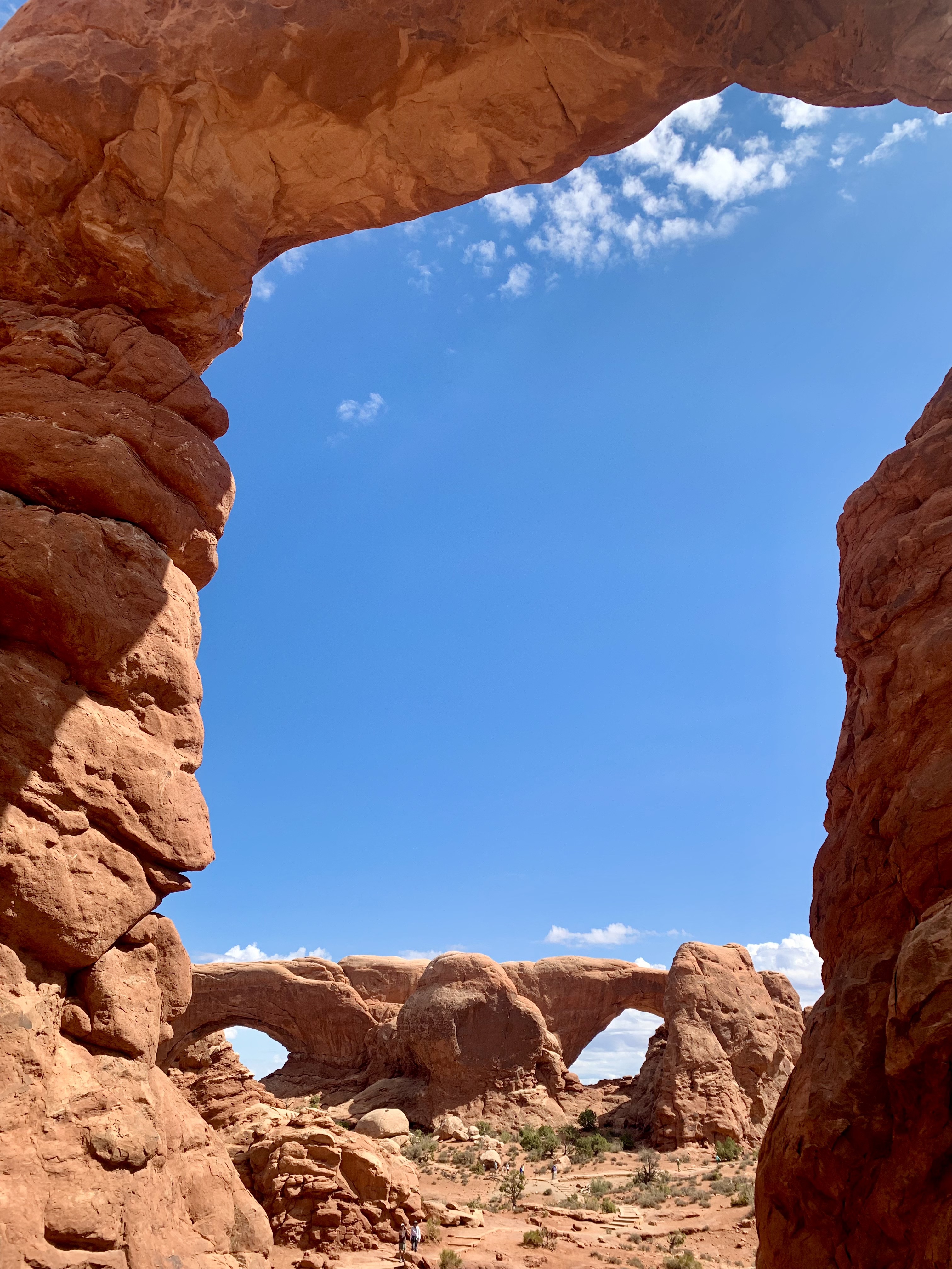
Windows Double Arch: North and South Windows Arches are intertwined and right off the road. Once again the views are to die for with a magnificent 360 degree grand view. We both did an easy scramble to the top and ended the hike at Turret's Arch down the way with the Window Arches in the background.
 |
| North Window's Arch |
 |
Windows Arches view
from Turret's Arch
|
 |
| Hanging Rock |
We didn't have time to gp the Delicate Arch, of course this is the one you see on all the postcards, but that's ok and now have a reason to go back. On our way back to Moab we were pulled over by the Parks POLICE. It took the young whipper snapper 20 minutes to get to the reason he pulled us over. He grilled us with important questions like: "is this your car", duh! "Do you have any warrants out on you"? Hmm.. do I look suspicious? What's in the back? Roll your window down-- Duh, camping gear officer. Registration, DL and your first born please. I figured he spotted our CA license plates, and since Big Red has a beat up look and is quite the charmer, he was sure he could come up with something more-- nope, no dope, clean as a whistle. Oh, he finally said do you want to know why I pulled you over--actually, not really, a Broken tail light. So Loraine and I went into town found the local Napa store and spent an hour so fixing the old girl.  |
| A Grand Canyon view |
Canyonlands National Park was next on our list: And wow, quite the opposite of Arches. This is Utah's largest park and least visited. I was reading a book in the National Park Mystery Series by Scott Graham called, "Canyonlands Carnage", what an insightful read. Didn't know this place has the most outrageous rapids in the country. Inside the park there is a place called Cataract Canyon with death defying rapids where the Colorado and the Green River converge, called a confluence. Scott Graham builds the store of shooting the rapids with a group of conservationists and big money people--agriculture, mining etc. in a hopeful chance they will witness the splendor and work together on how to allocate the future water supply to the southwest states. Agriculture in Imperial Valley, east of El Centro, uses as much as 50% of the Colorado River water. Agriculture is not a very efficient way to use the river water. Gee, maybe we should figure out a more clever way to water our crops (like drip systems) instead shooting the sprinkler sprays like a cannon up in the heated air for evaporation. And the alfalfa which is grown there is not even used by the average American, it is used as ballast in cargo ships headed to China, where it is fed to their cattle to just get rid of it. Therefore, we continually have a water crisis in the Southwest with many drought years in our future. An interesting side note is Canyonlands NP was established only in 1964 by a mishap.
 |
I can't imagine losing this
area to a dam |
The then Secretary of State, Stewart Udall was invited by the Bureau of Reclamation dam builder Floyd Dominy in 1961, to fly over it in his small plane, so he could show him where they could build the next dam. Dominy was famous for his dam building, but instead Udall saw this as the next national park. And within 3 years working with the various government branches, he guided them to set this area aside as a National Park. Thank goodness, because what you see makes the Grand Canyon seem like a smaller hole in the ground. I decided to try one trail down called the Gooseberry Trail.  |
There is a trail there
somewhere! |
Another interesting choice in my life--straight down with loose rocks, and slippery steps all the way down. I made it pretty close to the bottom about a 1,500' descent, and when I looked up to see where I had to go... I thought to myself- that's straight up! and thank goodness nobody else was on the trail accidently bumping rocks down the cliff side. I recommend at least 2/3 days to explore these parks.  |
Glen Canyon dam
on the Green river |
We stopped in Page, AZ for our last major base adventure, and took in the Glen Canyon dam which holds back lake Powell. This brought a lot of memories back for Loraine who spent many times here as a teenager skiing, jet skiing, houseboating and hiking. She was very emotional which she saw the water level drop of Lake Powell from her youth, but a dip in the lake seem to help her deal with it. The Glen Canyon dam is huge! And provides close to 5 million homes with electricity.
 |
| Lake Powell--going down! |
 |
| Heart shot |
 |
| Antelope Slot Canyon |
For pure, untouched, breathtaking beauty, this ranks up there with Iguazu Falls, Brazil. This is the only place I have seen where everyone is a great photographer. As matter of fact one spot is called the 6.5 million dollar shot, taken by National Geographic for its front cover of the magazine.
 |
| I don't want to die! |
Hikers beware though, these canyons are subject to flash floods. It is hard to believe just a few weeks ago, during a major storm, water was screaming through this canyon head high. After 6 weeks on the road we sat atop Horseshoe Bend in Page, AZ, realizing the trip was winding down, and time to boomerang back home. But we first had to stop and visit one of our favorite heart strings- Sedona, AZ, for one last hike and view of our precious resources. This always remind us of what a special country we live in, with all of its many treasures and adventures waiting to be explored.
 |
Horseshoe Bend below the
Glen Canyon dam |
 |
| Snoopy rock in Sedona |
One last thought. Protecting our Wilderness is not to be taken for granite. This picture in the 09/2022 issue of National Geographic of the Citadel in Utah's "Big Ears" National Monument, reminds us this area is an American treasure, which was almost lost to us to by a political decision for political gain. Keeping the area as a National Monument protects the land on a National level, (like Mount Rushmore National Memorial) it doesn't take away the leases for mining etc. which are already in place. This area is not only full of spectacular scenery it is a cultural heritage site for many Native American Tribes. If it had been returned to Utah they could have sold off the land to the highest bidders for mining and other resources. So please keep voting, and pay attention to what the politicians stand for when it comes to our future generations, so our children, and their children can experience the "Grand Circle of Life". Big Ears National Monument


Great story and Pic's Jerry!
ReplyDelete